Whilst I was looking looking for inspiration and doing some research for my current art practice I kept stumbling upon these navigation stick charts from the Marshall Islands, I have been thinking about these for some time and how I could adapt and incorporate them in to my work practice.
I remember seeing some examples of these navigation charts in the Oceania exhibition held at the Royal Academy in 2018. I started. looking through the catalogue from this exhibition to see what it said about these charts.
There was not much information but what there was Kind of struck a chord this section especially
“They mastered, managed and acculturated the ocean, the water; made it semiotically legible as an extension of the sense of place. Marshall Islanders created weather charms to aid navigators at sea and made “stick charts” as teaching aids and mnemonic devices for remembering the patterns of sea currents and ocean swells in relation to the location of islands within an archipelago. Islanders maritime arts replete with images and narratives of natural and supernatural creatures, from frigate birds to crocodiles, whose powers are harnessed to the purposes. They populate the water creeks, rivers , estuaries, seas. and oceans with protective guardians and spirits”
I also like this section of the writing from the Oceania catalogue
“However the water is also a metaphor for an element of grief and loss. It is a graveyard of. voyagers who never returned, navigators lost away. It is the element that separated people from the homes or origins elsewhere, and a metaphor for the inevitable forgetting of who they were in the transformation becoming who they are as a new people in a new time and a new place.”
AdmittedlyI found this section of writing interesting the idea of grief and loss being related to the vastness of the ocean, especially having spent many years dealing with the grief and loss of my wife and trying to make some sense of it through my art practice.
So can I use or appropriate a version of the stick charts to map my own mythology? I have the materials dowel, raffia and hag stones to use within these pieces. I expect the only way I will find this out is to make a version of a stick chart.
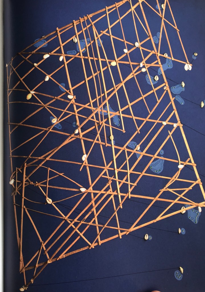
the stick chart in the photograph was made in the 19th century and comes from the Marshall Islands, is made of wood, fibre and snout shells and it is owned by the National Museum of Denmark.
Through researching a bit more on the Internet I came across this article on the subject of stick navigation
How Marshall Islanders navigated the sea using only sticks and shells, by Eric Grundhauser ,it is from Atlas Obscura.com and was written in October 2015
this section describes how the charts were used up navigate a you can have a safety
The stick charts of the Marshall Islands, in use since they were first inhabited in the 2nd century BCE, are simple-seeming navigational tools that look like little more than a bunch of twigs arranged into a loose lattice. They guide voyagers by depicting the waves and islands they are likely to encounter along the way. But unlike most maritime maps as we understand them today, the delicate stick charts were not brought on sea voyages. Instead, they were studied by the sailors prior to the trip. The directions and swells would be memorized by the mariners, who would then navigate without them.
there are three different types of stick charts Eric Grundhauser describes them below
The first type of chart was known as a “Mattang“. These charts were generally smaller and used mainly for instruction in the swell patterns of specific voyages, or in how to read a specific swell. These were often more abstract and symbolic, made by specific sailors for personal use, making them a bit more esoteric to the outsider. In these, as in all stick charts, the lines could be straight or curved or intersecting to represent the motion of the waves.
The second type of chart was the”Medo” chart which generally showed the relative position of a small number of islands to one another, and how their landmass’ swells presented and/or interacted. Unlike the mattang chart, the medo, was more concerned with the concrete position of islands, although again the oceanic swells were used to aid in navigation.
Finally the most far-reaching type of stick chart was the “Rebbelib“, which covered a much wider area, and a great many more islands. These charts, with their greater number of intersecting points often looked like a loose mesh of criss-crossing lines, dotted with shell markers. Some of these charts, which were not made to scale, could cover nearly the entirety of the Marshall Islands, which are spread over 750,000 square miles of the Pacific.
the charts are really beautiful pieces of functional folk art that are still in use.
